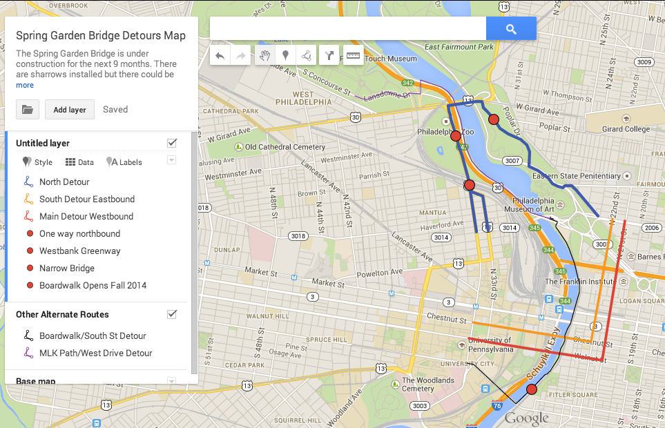
PennDOT has begun construction on the Spring Garden St Bridge and as a result the bike lanes have been replaced by sharrows for the duration of the project. The bridge rehabilitation will completed by the summer of 2015 and the bike lanes will be restored.
That won’t be a problem to many, other than congestion may slow your trip. But if you would rather select a less stressful route to cross the river then we offer a few suggestions.
The Walnut St and Chestnut St Bridges are the best detours between University City and the Fairmount/Spring Garden neighborhoods, but if you want to trade your speedy commute for a longer, lower stress alternative consider these three routes.
Schuylkill River Trail Boardwalk and the South Street Bridge – You’ll have to wait about a month or so before the Boardwalk opens, but when it does, the views will be worth the detour. The downside to this mostly traffic free route are the peak afternoon crowds on the Schuylkill Banks, which will only grow with the boardwalk’s opening.
MLK Drive Path – The bridge over the Schuylkill is a challenge due to its 5 foot sidewalk but like the above much of the trip is off road and alongside the Schuylkill. The left turn off the path onto Sweet Briar Drive and then Lansdowne Drive is somewhat difficult in rush hour traffic. Its the best way to the West Park attractions and Overbrook.
Sedgley Drive and the Girard Avenue Bridge – Did you know about the Westbank Greenway extension on east side of 34th Street across from the Philadelphia Zoo? Give yourself an extra 15 minutes on your trip to or from the Drexel University area to try it out . It’s a bit of renegade route, especially if you traveling westbound. Sedgely begins across Kelly Drive from Lloyd Hall and becomes one way southbound north of Lemon Hill Drive. But the yellow striped shoulder serves as an ad-hoc contra flow lane (we don’t recommend the dilapidated sidepath). Walk your bike on the Girard Ave Bridge sidewalk. Although the sidewalk is 12 feet wide (standard for shared use paths) it is illegal to bike there. At the west end of the sidewalk on 34th St near the zoo entrance there is a junction with the new path. Farther south on 34th on the bridge over Amtrak there is a very short northbound buffered bike lane, southbound trail users are expected to use the bridge sidewalk (in contradiction with Philadelphia bicycle regulations). From there you can head south on 34th or continue on the Westbank Greenway into University City

Sedgely Drive

34th and Girard

34th over Amtrak


As a bicycle commuter who has seen the arrows on the street I never knew what a “sharrow” was. I’d be willing to bet <1% of motorists know. There's been no evidence during my riding that a sharrow has any effect on motorist behavior.
Is there a campaign to explain/promote their meaning?
We have a page on our website with a glossary of pavement markings. https://bicyclecoalition.org/ride-your-bike/signs-symbols-glossary/.
The City’s 2013 bike map also defines the terms. http://www.scribd.com/doc/212320300/2013-Philadelphia-Bike-Map
But, as far as a public service ad campaign directed at motorists, no there isn’t one.
I use the Girard Street bridge every day riding to and from work.
I wish they would divide the sidewalk in half so cyclists could have a safe stretch to ride across. The people that drive over that bridge are awful, and there are drains on shoulder in the road.
Maybe someday…